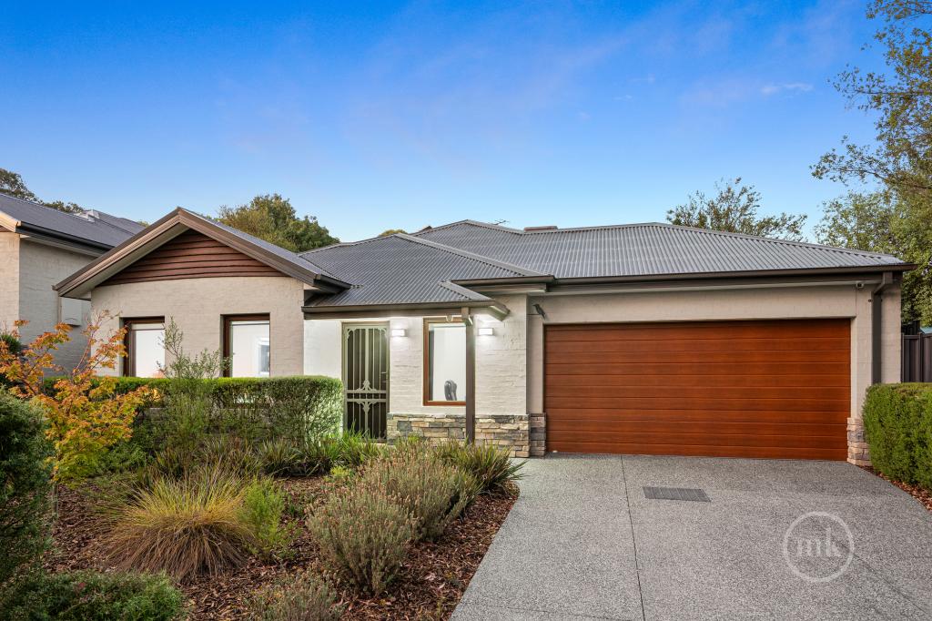
1 Acworth Court, Greensborough, VIC 3088 | Property Value & History | OnTheHouse
OFF MARKET
Are you the owner?

1 Acworth Court
Greensborough VIC 3088

Bedrooms: 3
Bathrooms: 2
Car spaces: 2
Floor area: 200m2
Land area: 717m2
Estimated Value & Rent
Estimated Value
Estimated Rent
Medium Confidence
Last updated 26 May 2025
Low

High
$1.00M
$1.10M
Save

Property Details for 1 Acworth Ct, Greensborough

1 Acworth Ct, Greensborough is a 3 bedroom, 2 bathroom House with 2 parking spaces and was built in 1980. The property has a land size of 717m2 and floor size of 200m2. While the property is not currently for sale or for rent, it was last sold in March 2015.

Building Type
House
Year Built
1980
Floor Size
200m2
Land Size
717m2
Local Government
Nillumbik
Lot/Plan
227/LP133623

Last Listing description (May 2015)

Unique in design and extensive in its living spaces, this light filled home also enjoys the benefits of a level rear yard, a huge garage/workshop and a sought after Apollo Parkways position! The updated kitchen, finished in stainless steel appliances, serves a very generous family living zone, and is perfectly positioned so you can watch the kids in the yard as you get dinner ready. Complementing this impressive space is a rumpus room for the kids along with a vast casual living zone under soaring ceilings and an equally spacious formal living with balcony access and a very handy study nook. Those in the main bedroom will appreciate the ensuite, while the rest have the family bathroom to keep them happy!
Ducted heating and cooling

Large outdoor area in deep level rear yard
Easy walk to shops, schools and parklands
Bus just moments away
Huge garage and workshop
Relaxing tree top views from balcony
Four expansive living zones
PHOTO ID IS REQUIRED AT ALL OPEN FOR INSPECTIONS

Property History for 1 Acworth Ct, Greensborough, VIC 3088

A timeline of how this property has performed in the market
Last Sold
$542,500
28 Mar 2015
  • 28 Mar 2015
    Sold for $542,500
  • 23 Feb 2015
    Listed for Sale Price Guide $490,000 to $540,000
  • 24 Jul 2012
    Sold for $480,000
Sign in to see more transactions

Commute Calculator

Where to?
-
-
-
-

Local Area Liveability Score

2.4

This Liveability Score is a rating "out of 10" and a guide to how well connected properties within a local area are to facilities such as public transport, healthcare services, shopping outlets, schools and parkland. The scores apply to the local area (or "mesh block") in which a property is located. The scores are largely comprised of 2 main elements:

  1. Walking time to a local facility
  2. Number of facilities within a 20-minute walk

The overall Liveability Score is made up of smaller sub-scores, as described below.

Sign up or Login to see liveability score in more detail
Walkability
10/10
Schools
10/10
Parklands
10/10
Health
10/10
Shopping
10/10
Public Transport
10/10

About Greensborough 3088

The size of Greensborough is approximately 10.2 square kilometres. It has 41 parks covering nearly 12.1% of total area. The population of Greensborough in 2011 was 20,552 people. By 2016 the population was 20,803 showing a population growth of 1.2% in the area during that time. The predominant age group in Greensborough is 40-49 years. Households in Greensborough are primarily couples with children and are likely to be repaying $1800 - $2399 per month on mortgage repayments. In general, people in Greensborough work in a professional occupation. In 2011, 81.6% of the homes in Greensborough were owner-occupied compared with 80.4% in 2016.

Greensborough has 10,006 properties. Over the last 5 years, Houses in Greensborough have seen a 25.84% increase in median value, while Units have seen a 15.29% increase. As at 30 April 2025:

  • The median value for Houses in Greensborough is $1,072,903 while the median value for Units is $713,390.
  • Houses have a median rent of $605 while Units have a median rent of $530.
There are currently 34 properties listed for sale, and 3 properties listed for rent in Greensborough on OnTheHouse. According to CoreLogic's data, 326 properties were sold in the past 12 months in Greensborough.

What's around 1 Acworth Ct, Greensborough

1 Acworth Ct, Greensborough is in the school catchment zone for Apollo Parkways Primary School and St Helena Secondary College.

Nearby Schools
Comparable Properties
Diamond Valley Special Developmental School
0.44km
Greensborough 3088
SpecialGovernmentCombined146 Enrolled
Apollo Parkways Primary School
0.57km
Greensborough 3088
IN CATCHMENTPrimaryGovernmentP - 6Combined819 Enrolled
Greenhills Primary School
1.12km
Greensborough 3088
PrimaryGovernmentP - 6Combined526 Enrolled
Plenty Valley International Montessori School
2.15km
St Helena 3088
PrimaryNon-GovernmentP - 6Combined66 Enrolled
St Helena Secondary College
2.41km
Eltham North 3095
IN CATCHMENTSecondaryGovernment7 - 12Combined1584 Enrolled
Glen Katherine Primary School
2.54km
Eltham North 3095
PrimaryGovernmentP - 6Combined566 Enrolled
Greensborough Primary School
2.61km
Greensborough 3088
PrimaryGovernmentP - 6Combined168 Enrolled
Holy Trinity Primary School
2.62km
Eltham North 3095
PrimaryNon-GovernmentP - 6Combined381 Enrolled
Briar Hill Primary School
2.83km
Briar Hill 3088
PrimaryGovernmentP - 6Combined193 Enrolled
Sherbourne Primary School
3.25km
Briar Hill 3088
PrimaryGovernmentP - 6Combined187 Enrolled

Suburb Insights for Greensborough 3088

Market Insights
Greensborough Trends for Houses
Median Value

N/A

-
View Trend
Median Growth

N/A

View Trend
Median Rent

N/A

-
View Trend
Rental Yield

N/A

-
View Trend
Median Value: The middle value of all properties across the geography based on the Automated Valuation Model.


Median Value over 1 year
Greensborough Trends for Units
Median Value

N/A

-
View Trend
Median Growth

N/A

View Trend
Median Rent

N/A

-
View Trend
Rental Yield

N/A

-
View Trend
Median Value: The middle value of all properties across the geography based on the Automated Valuation Model.


Median Value over 1 year
Neighbourhood Insights
Age

Population 20,803

0-9


13%

10-19


11%

20-29


11%

30-39


14%

40-49


14%

50-59


13%

60-69


12%

70-79


7%

80-89


3%

90-99


1%

Household Structure
Occupancy
Disclaimer
Whilst all reasonable effort is made to ensure the information in this publication is current, CoreLogic does not warrant the accuracy or completeness of the data and information contained in this publication and to the full extent not prohibited by law excludes all liability for any loss or damage arising in connection with the data and information contained in this publication.
Victoria data
The State of Victoria owns the copyright in the Property Sales Data and reproduction of that data in any way without the consent of the State of Victoria will constitute a breach of the Copyright Act 1968 (Cth). The State of Victoria does not warrant the accuracy or completeness of the Property Sales Data and any person using or relying upon such information does so on the basis that the State of Victoria accepts no responsibility or liability whatsoever for any errors, faults, defects or omissions in the information supplied.
Valuations and Estimates
This estimate is provided by CoreLogic, and is based on statistical market data such as recent local sales, property size, number of bedrooms and many more factors. It comes from public data, which may be incomplete or inaccurate, and should not be used in lieu of a professional appraisal under any circumstances, including for lending purposes or in home loan applications.
School data and Content
Product Data licenced by CoreLogic under a Creative Commons Attribution licence. For details regarding licence, data source, copyright and disclaimers, see https://www.corelogic.com.au/legals/third-party-restrictions
ABS data
This publication contains data and statistics provided by the Australian Bureau of Statistics, available at http://www.abs.gov.au/ and reproduced under Creative Commons Attribution 2.5 http://creativecommons.org/licenses/by/2.5/au/legalcode
Liveability information
The Liveability Score is a rating (out of 10) provided by Propella.ai Pty Ltd as a guide about how "well-connected" properties are in certain local areas. The Liveability Score is based on statistical data about a local area in which a property is located including the distance to and number of available facilities and services (including schools, parklands, health services, shopping and public transport) (Liveability Data). The Liveability Data and Liveability Score has not been verified or confirmed by CoreLogic, is not available for all properties, and is of a general nature and should not be construed as specific advice or relied upon in lieu of appropriate professional advice. Given the relative nature of the Liveability Score, propella.ai anticipate that scores for individual properties will change over time.