1 Austral Park RoadParattah TAS 7120
Thinking about insurance?
Get estimated rebuild costs for this property with Sum SureProperty Details for 1 Austral Park Rd, Parattah
1 Austral Park Rd, Parattah is a bedroom, bathroom House. The property has a land size of 46500m2.
Last Listing description (January 2025)
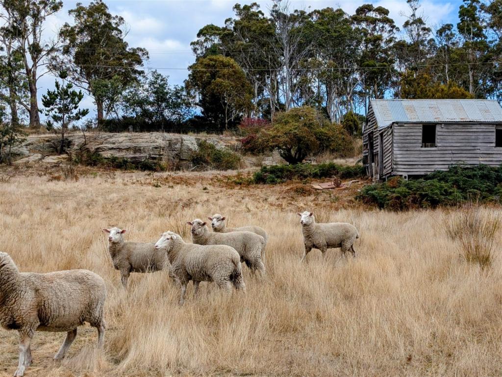
Only 7 minutes from the southern Midlands hub of Oatlands and nestled in the close-knit historical village of Parattah, this large parcel of land offers a fantastic rural aspect with your own private native bush reserve as a backdrop.
It offers a number of private sheltered building sites on the property taking in the 180 degree views towards Table Mountain in the west, nearby Lake Dulverton and Mt Seymour in the east and further north towards Vincent's Hill.
The 4.844ha (11.95 acres) has been divided into 2 well-fenced paddocks with the added bonus of a three-room Colorbond 'Humpy'.
The 'Humpy' is offered as 'walk-in/walk-out' and contains an extensive collection of tools, camping equipment, a BBQ/kitchen area, camp shower and Suburu Forester. Acting a secure shelter the 'Humpy' is connected to 2 above ground water tanks.
In recent times, the fertile 11.95 acres has been used as agistment for horses and has a large storage dam in the south west corner of the block.
A series of tracks/pathways have been marked into the bush reserve on the property - ideal for exploring and admiring the natural Tasmanian eucalyptus forest.
Established in 1876, Parattah was a thriving railway township, which has now transformed into a close-knit community of around 100 residents. With strong ties to the timber, agricultural and railway industries, Parattah has several historic buildings lovingly restored by its residents.
To construct your home or hobby farm, Lot 1 Austral Park Road, Parattah represents a fantastic opportunity. For more information, copy of titles and/or video tour of the 'Humpy' feel free to contact Nick Hay at Howell Property Group.
Facts:
PID: 2948938
Title Reference: 224832/1
Tank and Septic Sewer System required.
Council Rates: $508 p/y approx.
Land Size: 4.8344 Ha (11.75 acre) approx.
Council: Southern Midlands Council.
The information has been supplied to us, and we have no reason to doubt its accuracy; however, we cannot guarantee it. Accordingly, all interested parties should make their own enquiries to verify this information.
Property History for 1 Austral Park Rd, Parattah, TAS 7120
- 06 Sep 2024Listed for Sale Not Disclosed
Recent sales nearby
See more recent sales nearbySimilar properties For Sale nearby
See more properties for sale nearbyAbout Parattah 7120
The size of Parattah is approximately 18.5 square kilometres. It has 5 parks covering nearly 0.3% of total area. The population of Parattah in 2016 was 159 people. By 2021 the population was 147 showing a population decline of 7.6% in the area during that time. The predominant age group in Parattah is 50-59 years. Households in Parattah are primarily childless couples and are likely to be repaying $600 - $799 per month on mortgage repayments. In general, people in Parattah work in a trades occupation.In 2021, 85.30% of the homes in Parattah were owner-occupied compared with 83.90% in 2016..
Parattah has 89 properties. Over the last 5 years, Houses in Parattah have seen a 65.69% increase in median value. As at 31 July 2025:
- The median value for Houses in Parattah is $434,303.
What's around 1 Austral Park Rd, Parattah
1 Austral Park Rd, Parattah is in the school catchment zone for Oatlands District High School.


Suburb Insights for Parattah 7120
Market Insights
Parattah Trends for Houses
$434k
10.32%
View TrendN/A
5.47%
Parattah Trends for Units
N/A
N/A
View TrendN/A
N/A
Neighbourhood Insights
Age
Population 147
0-9
8%
10-19
14%
20-29
8%
30-39
2%
40-49
19%
50-59
24%
60-69
15%
70-79
5%
Household Structure
Occupancy
© Copyright 2025. RP Data Pty Ltd trading as Cotality (Cotality). All rights reserved. No reproduction, distribution, or transmission of the copyrighted materials is permitted. The information is deemed reliable but not guaranteed.
While Cotality uses commercially reasonable efforts to ensure the Cotality Data is current, Cotality does not warrant the accuracy, currency or completeness of the Cotality Data and to the full extent permitted by law excludes all loss or damage howsoever arising (including through negligence) in connection with the Cotality Data.
(a) give no warranty regarding the data's accuracy, completeness, currency or suitability for any particular purpose; and
(b) do not accept liability howsoever arising, including but not limited to negligence for any loss resulting from the use of or reliance upon the data.
Base data from the LIST © State of Tasmania http://www.thelist.tas.gov.au.
This publication contains data and statistics provided by the Australian Bureau of Statistics (ABS Data). ©2025 Copyright in this information belongs to the Australian Bureau of Statistics (ABS). The ABS provides no warranty that the ABS Data is free from error, complete or suitable for any particular purpose.


/assets/perm/hkakte752yi6tny24n4nk2fa5e?signature=0f248d9b6ba36348026f7f557ec7d4240e16a02fe93644e89aa2007de582c56f)
/assets/perm/b25racdp7yi63dj4wvvnemssfa?signature=faf6a5f914008ca0bf4631659eaf08b7fdd772400945c06c9c21b35d09e984ef)


