
32 Tamblyn StreetSpalding WA 6530
Property Details for 32 Tamblyn St, Spalding
32 Tamblyn St, Spalding is a 1 bedroom, 0 bathroom House. The property has a land size of 29713m2. While the property is not currently for sale or for rent, it was last sold in August 2025. There are other 1 bedroom House sold in Spalding in the last 12 months.
Last Listing description (September 2025)
Phone Enquiry Property ID: 2712 (Quote when calling or texting)
Residential Development R20 zoning
29,713sqm Total Land Area
Adjacent to other established residential subdivisions
Concept Plan for a 28-Lot subdivision ranging from 734sqm 900sqm each.
Potential for over 40-Lots with R20 zoning with an average of 450sqm per lot.
Flat and most cleared development site
All services available including scheme water, deep sewerage, electricity, NBN.
Potential Retirement living (STCA)
Landbank opportunity, invest in your future
At this price, the property equates to UNDER $27 per square metre!
An exciting opportunity exists for an astute buyer with this huge 29,713sqm residential development block, ideally positioned only 3.8km from Geraldton town centre and is surrounded by existing residential subdivisions. The property has the current zoning and potential to be subdivided into individual blocks, a housing estate or strata development. Buy now at this low price and landbank for the future.
The site is zoned Residential Development with a density code of R20 under the City of Geraldtons Local Planning Scheme. The site has a land area of 29,713, with street frontages to Tamblyn Street and Hamersley Street. Its flat and is mostly cleared of all native vegetation.
Concept plans are designed for a 28-lot subdivision with the potential for more than 40-Lots with the current R20 zoning at an average of 450sqm per lot. Considering this location, it seems likely there will be interest for a housing estate, retirement living, over 55s village and other approved residential-zoned uses to take advantage of the surrounding demographics and facilities.
Theres scheme water, electricity and deep sewerage networks all around the property, surrounded by existing residential homes and infrastructure.
This large residential development property is easily accessible to public transport, schools, medical facilities and nearby shopping centres. Its only minutes from all the amenities of the Geraldton CBD and only 1.2km from the beach.
The City of Greater Geraldton has excellent medical, education, sporting, trade and shopping amenities, benefits from economic activity in the mining, agriculture, tourism and fishing industries and is positioned to become a hub for renewable energy, logistics and general services to other major regional areas of Western Australia.
Property History for 32 Tamblyn St, Spalding, WA 6530
- 22 Aug 2025Sold for $899,800
- 01 Jul 2025Listed for Sale Offers From $795,000 +gst
- 21 Sep 2021Sold for $305,000

Recent sales nearby
See more recent sales nearbySimilar properties For Sale nearby
See more properties for sale nearby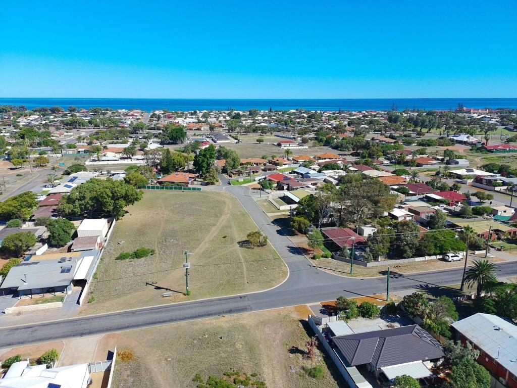 0
0 0
0 0
0
Similar properties For Rent nearby
See more properties for rent nearby 0
0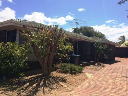 0
0 0
0
About Spalding 6530
The size of Spalding is approximately 4.4 square kilometres. There are 7 parks, covering nearly 64.0% of the total area. The population of Spalding in 2016 was 2075 people. By 2021 the population was 1992 showing a population decline of 4.0% in the area during that time. The predominant age group in Spalding is 10-19 years. Households in Spalding are primarily childless couples and are likely to be repaying $1000 - $1399 per month on mortgage repayments. In general, people in Spalding work in a labourer occupation.In 2021, 63.40% of the homes in Spalding were owner-occupied compared with 58.30% in 2016.
Spalding has 1,008 properties. Over the last 5 years, Houses in Spalding have seen a 120.50% increase in median value, while Units have seen a 173.02% increase. As at 31 May 2026:
- The median value for Houses in Spalding is $550,538 while the median value for Units is $459,273.
- Houses have a median rent of $480 while Units have a median rent of $200.
Suburb Insights for Spalding 6530
Market Insights
Spalding Trends for Houses
N/A
N/A
View TrendN/A
N/A
Spalding Trends for Units
N/A
N/A
View TrendN/A
N/A
Neighbourhood Insights
© Copyright 2026. RP Data Pty Ltd trading as Cotality (Cotality). All rights reserved. No reproduction, distribution, or transmission of the copyrighted materials is permitted. The information is deemed reliable but not guaranteed.
While Cotality uses commercially reasonable efforts to ensure the Cotality Data is current, Cotality does not warrant the accuracy, currency or completeness of the Cotality Data and to the full extent permitted by law excludes all loss or damage howsoever arising (including through negligence) in connection with the Cotality Data.
This product uses cookies and other similar technologies to improve and customise your browsing experience, to tailor content and adverts, and for analytics and metrics regarding visitor usage on this product and other media. We may share cookie and analytics information with third parties for the purposes of advertising. By continuing to use our website, you consent to cookies being used. View our Privacy Policy here.
X