
29 Drysdale RoadWarrandyte VIC 3113
Property Details for 29 Drysdale Rd, Warrandyte
29 Drysdale Rd, Warrandyte is a 3 bedroom, 1 bathroom House with 1 parking spaces and was built in 1970. The property has a land size of 755m2 and floor size of 130m2. While the property is not currently for sale or for rent, it was last sold in April 2022.
Last Listing description (August 2022)
Immersed in a private native setting in this prized, elevated Warrandyte pocket, merely minutes to cafes, shops, Yarra River walks and schools, this beautifully reimagined home promotes an enviable lifestyle.
Seamlessly renovated throughout with a light bathed style that embraces some of the home's original character traits while creating a distinct modern edge. Displaying four bedrooms and two alluring contemporary bathrooms with skylights plus a powder room; main bathroom with a deep bath and floating vanity. The master boasts built-in robes and a modern fully tiled ensuite with shower niche. A large laundry adds more space for a busy family with a whole wall of cabinetry storage and external entry.
Hardwood Tasmanian Oak floors flow throughout the open plan, single level design with living and dining featuring an integrated gas log fire offset by built-in streamlined cabinetry with LED back lighting creating atmosphere. A high-end kitchen sits at the helm, connected by a breakfast bar and stone benchtops. Displaying a stainless-steel electric wall oven, gas cooktop and dishwasher. Enhanced by its premium 2-Pac cabinetry with European hinge fittings and a soft-toned subway feature tile splashback that adds a friendly warmth to the space.
Outdoor entertaining beckons from the fully fenced front of home eco deck and sizeable gardens flowing around the generous allotment. A separate firepit area is ideal for parties and the garden bursts with fruit trees encompassing plums, apple, pear, nectarine and a lemon for all your summer drinks. Raised veggie garden boxes are primed for sowing your first crop.
Ideal for couples and young families, displaying; hydronic heating, evaporative cooling, a split system, ceiling fan in master, double blinds, linen press, water tank and carparking for three cars approx.
Goldfields shops and services are just down the hill, with Yarra Street bakeries, restaurants, bars and cafes an extra enticement. A short drive to Aumanns gourmet produce store, The Pines Shopping Centre, Templestowe Village and Westfield Doncaster. Minutes stroll to Stiggants Reserve and Anderson Creek Primary and handy links to Donvale Christian College and Carey Grammar. Close to the freeway and CBD or Ring Road to the airport.
Property History for 29 Drysdale Rd, Warrandyte, VIC 3113
- 12 Apr 2022Sold for $1,150,000
- 15 Mar 2022Listed for Sale $1,179,000
- 19 Jul 2019Sold for $755,000

Recent sales nearby
See more recent sales nearby
Similar properties For Sale nearby
See more properties for sale nearby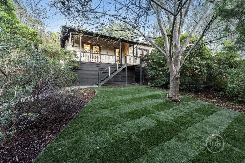 0
0 0
0 0
0About Warrandyte 3113
The size of Warrandyte is approximately 17.6 square kilometres. There are 20 parks, covering nearly 27.2% of the total area. The population of Warrandyte in 2016 was 5502 people. By 2021 the population was 5541 showing a population growth of 0.7% in the area during that time. The predominant age group in Warrandyte is 50-59 years. Households in Warrandyte are primarily couples with children and are likely to be repaying $1800 - $2399 per month on mortgage repayments. In general, people in Warrandyte work in a professional occupation.In 2021, 91.00% of the homes in Warrandyte were owner-occupied compared with 90.30% in 2016.
Warrandyte has 2,285 properties. Over the last 5 years, Houses in Warrandyte have seen a -10.13% decrease in median value, while Units have seen a 14.13% increase. As at 30 June 2026:
- The median value for Houses in Warrandyte is $1,312,731 while the median value for Units is $881,979.
- Houses have a median rent of $950.
Suburb Insights for Warrandyte 3113
Market Insights
Warrandyte Trends for Houses
N/A
N/A
View TrendN/A
N/A
Warrandyte Trends for Units
N/A
N/A
View TrendN/A
N/A
Neighbourhood Insights
© Copyright 2026. RP Data Pty Ltd trading as Cotality (Cotality). All rights reserved. No reproduction, distribution, or transmission of the copyrighted materials is permitted. The information is deemed reliable but not guaranteed.
While Cotality uses commercially reasonable efforts to ensure the Cotality Data is current, Cotality does not warrant the accuracy, currency or completeness of the Cotality Data and to the full extent permitted by law excludes all loss or damage howsoever arising (including through negligence) in connection with the Cotality Data.
This product uses cookies and other similar technologies to improve and customise your browsing experience, to tailor content and adverts, and for analytics and metrics regarding visitor usage on this product and other media. We may share cookie and analytics information with third parties for the purposes of advertising. By continuing to use our website, you consent to cookies being used. View our Privacy Policy here.
X